Archive for the ‘Pusch Ridge WIlderness’ Tag
Pusch Ridge Wilderness, Santa Catalina Mountains — Photo-Artistry by kenne
The path to Han-shan’s place is laughable,
A path, but no sign of cart or horse.
Converging gorges – hard to trace their twists
Jumbled cliffs – unbelievably rugged.
A thousand grasses bend with dew,
A hill of pines hums in the wind.
And now I’ve lost the shortcut home,
Body asking shadow, how do you keep up?
— Han-shan
Wilderness of Rocks, Pusch Ridge Wilderness Area (Santa Catalina Mountains) — Photo-Artistry by kenne
 Wilderness of Rocks In Pusch Ridge Wilderness — Images by kenne
Words by: Edward Abbey, Aldo Leopold, Ralph Waldo Emerson,
John Muir, and Wallace Stegner
 Wilderness Floor
 Lightning Struck The Pusch Ridge Area Causing The Bighorn Fire — Image by kenne
The Bighorn Fire began burning in the Santa Catalina Mountains north of Tucson on June 5th.
 It has now burned over 32,000 acres and is only 40% contained.
 Almost 1,000 personal with a lot of land and air support equipment continue to fight the fire.
 Images were taken about three miles from the front ridge of the range.
 Each image was captured at various times on June 18th.
 Images by kenne

 Bighorn Fire Air Assault Photos by kenne
Trying to get photos of the Bighorn Fire air assault from my patio in the eastern Catalina Foothills is not an easy trick. I’m licking a good location and the lens needed to do justice to the challenge.
Sharing these two images is meant so I can direct you to some photos taken by my good friend, Ned Harris. Here’s a link to his Flickr account:
https://www.flickr.com/photos/ned_harris/albums/72157714619211453
When it comes to aerial photos, he is among the best. Enjoy!
— kenne
 Sunset (June 12th, 2020)
The Bighorn Fire began June 5th in the Pusch Ridge Wilderness. After burning a lot the southwest area of the front ridge,
it has now moved northeast, having burned over 7,000 acres.
 Sunrise (June 13th, 2020) — Images by kenne
This morning with little or no wind, evidence of smoke appears to have gone from our viewpoint.
However, looks deceive, since containment remains a 10% and is projected to not be contained before June 25th.
— kenne
 Late Wednesday, June 10th. Most of the smoke is from upper Pima Canyon, Finger Rock and Mt. Kimball.
 Around 6:00 am Thursday, June 11th. The smoke has settled in over
the Catalina Mountains and beginning to move down into the Tucson basin.
 The smell from the fire is very noticeable as I leave for my
morning walk in the neighborhood.
 I’m now at the back of Tanuri Ridge as more of the smoke appears
to be leaving the mountains spreading over the Catalina Foothills.
I’m beginning to think I should have warned a facemask.
 Now at the entrance of Tanuri Ridge and you can bearly make out
the mountains.
 I used a Photoshop Dehaze filter on some of these images so in reality,
there was much more smoke and haze.
 Tanuri Drive
 As I continued my walk, the parts of the fire appeared to be
backtracking to the west.
 There’s very little wind this morning, so a lot of the news smoke
coming from downdrafts through where rain would typically
flow off the mountains.
 A big plum of smoke coming from the Finger Rock area.
 It is now around 8:00 am.
 It is now around 10:30 am. The fire is now about a mile west of
Pima Canyon trailhead. (Because of my distance from the
mountains, I’m making an educated guess.)
The following copy is from Haidi Chewel, with the National Forest Service.
Bighorn Fire – June 11th, 2020 Morning Update
Pima County Sheriff’s Department issues “SET” notice
Acres: 4,769 Percent Containment: 10%
Start Date: June 5th, 2020 Cause: Lightning
Origin Location: Santa Catalina Mountains
Jurisdiction: Coronado National Forest, including portions of the Pusch Ridge Wilderness
Personnel: 391
Resources: 6 hotshot crews, 3 Type 2 hand crews, 7 Type 3 engines, 1 Type 4 engine, 7 Type 6 engines, 4 Type 1 helicopters, 1 Type 2 helicopter, 2 Type 3 helicopter, 10 water tenders
The Bighorn Fire remained active overnight, with flames being pushed downhill by downslope winds. Temperatures up to 106 degrees today and continued low humidity will increase fire activity. The fire will again be highly visible on the front range of the Santa Catalina Mountains. Crews will work to hold the fire perimeter and continue building fire lines, tying into control features such as roads and rock outcroppings. Additional aerial resources will support the crews on the ground with water and retardant drops.
Over the next several days’ communities can expect to see crews and apparatus working in an around subdivisions in the Catalina Foothills. Members of the public are advised to drive with caution and leave roadways clear for emergency vehicles and equipment to pass.
At first glance, this may look like a volcano erupting.
 But, it’s the Bighorn Wildfire now having worked it’s way
 into Pima Canyon and the Finger Rock area of the Pusch Ridge Wilderness (June 10, 2020).
 The Sabino Canyon Volunteer Naturalists lead hikes twice a year on the Pima Canyon Trail to a natural dam (6 miles round trip).
— — Images by kenne


 Bighorn Wildfire In the Pusch Ridge Wilderness, Santa Catalina Mountains (June 9, 2020) — Images by kenne
The bighorn wildfire that was lightning-caused June 5, 2020, has now entered the upper elevation of Pima Cayon in the
Pusch Ridge Wilderness. The fire has now burned 3,277 acres. At various times, depending on wind conditions,
the mountains and foothills are covered with a haze of smoke. — kenne
 Smoke from the Bighorn Wildfire in the Pusch Ridge Wilderness, Santa Catalina Mountains (June 9, 2020) — Image by kenne
Yesterday, for the second time since June 5th, a drone was observed over
the Bighorn Fire’s southern perimeter. This unlawful event forced
the aircraft suppression effort to be halted, endangering the lives
of on the ground firefighters and the aircrews at a critical time
during the height of the burning period.
Incident Commander Lathe Evans explained that the percentage of containment
has not increased, and acreage burned has increased largely due to this
illegal drone incursion.
If You Fly, We Can’t!
 The Bighorn Wildfire burns in the Pusch Ridge Wilderness near Oro Valley on Saturday, June 6, 2020.
The fire was caused by lightning on the evening of June 5, 2020. — Christopher Conover/AZPM
The Bighorn Wildfire grew to about 200 acres on Saturday. Officials with the Coronado National Forest said Saturday afternoon
that three hotshot crews were on scene working to contain the fire.
Tanker planes and helicopters have been dropping fire retardant and water on the fire burning less than a mile from La Reserve.
The wildfire has impacted several trails in the Catalinas: Romero Canyon; Pusch Peak; Pima Canyon; Finger Rock; Ventana Canyon.
 Bighorn Wildfire smoke glows red and orange in the setting sun. — Image from his patio by kenne
 Shadows In The Woods (Pusch Ridge Wilderness Area, Santa Catalina Mountains) — B&W Image by kenne
 Pusch Ridge Wilderness, Santa Catalina Mountains — Image by kenne
“Wilderness. The word itself is music.
Wilderness. Wilderness… We scarcely know what we mean by the term,
though the sound of it draws all whose nerves and emotions have not been
irreparably stunned, deadened, numbed by the caterwauling of commerce,
the sweating scramble for profit and domination.”
— Edward Abbey
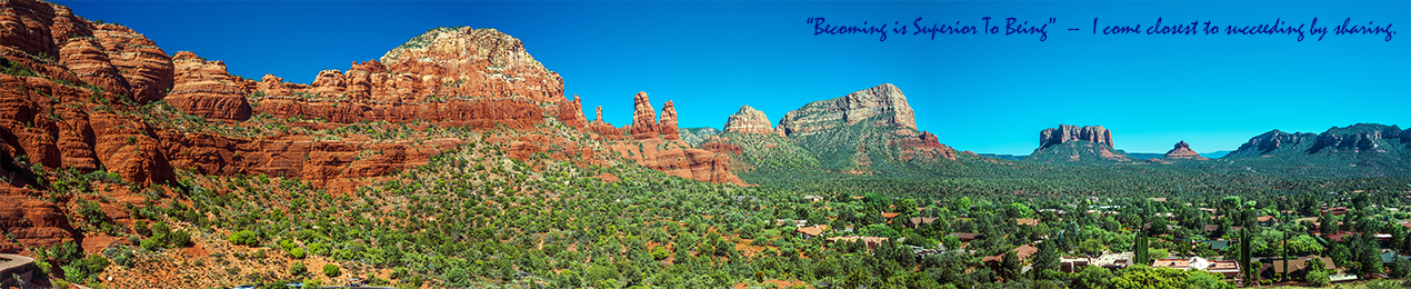
 Pusch Ridge Wilderness In the Santa Catalina Mountains– Panorama by kenne
Feel the thrill of being in the moment.
— kenne


 blog")


-3 blog")
 blog")

-2 blog")
 art blog")

 blog")

-2 blog")
 blog")

-2 blog")

-2 art blog")

-33 Pine Leaf Milkweed Pod blog")

-10 blog")


 blog")


 blog")
-17 blog")
-8 blog")

-6 blog")
-2 Two Nuns blog")
-27 blog")

-6 blog")
-11 blog")
-8 blog")


-5 blog")
-4 blog")
 art blog")
-5 blog")


 blog")
-4 blog")


-5 blog")


-2 blog")
 art blog")
-4-2_contrast blog")
-2 blog")
-3 blog")
-2 blog")

 blog")


 blog")

-2 blog")
-art blog")


 blog")
-9 blog")


 Art II blog")
-5 Balance Rock blog")

 blog")

 framed blog")
-2 blog")

-5 blog")
-9 blog")
 art blog")

-5 blog")


-28 blog")

 blog")


-14 blog")


_painting blog")
-4 blog")

-2 blog")

 blog")
-12 blog")


