Archive for the ‘Tucson Mountains’ Tag
 Catalina Foothills Smoked-filled Sunset, Monday, June 20, 2011 — Image by kenne
Late Monday afternoon, the skies got dark as the winds blow in smoke from the wildfires to our east. Here’s a short video showing the conditions Monday and how they had changed make to normal the following afternoon.
kenne
 Sharon & Woody Woodworth — Images by kenne
We first met Sharon and Woody on one of the Tucson Welcome Wagon hikes in February of this year. Like us, they had moved to Tucson last summer. From February through April we hiked several trails in the Santa Catalina and Tucson Mountains, and on some occasions Sharon, Woody, Joy and I would hike a little farther than the group. The last time we hiked together, we went out for breakfast.
Yesterday we got word that Woody passed away in his sleep, only a few weeks after learning he had brain cancer. Click here for a Flickr photo set.
“To live is to be photographed, to have a record of one’s life, and therefore, to go on with one’s life, oblivious, or claiming to be oblivious, to the camera’s non-stop attentions. But it is also to pose. To act is to share in the community of actions recorded as images.” — Susan Sontag
kenne
 One of the Seven Falls Crossings — Image by kenne
The song “Black Widow” was selected for this video, in February of this year, because I like the song without taking literally the lyrics.

 Hiking In The Tucson Mountains — Images by kenne (Flickr Photo Set – Click Here)
Most of the nearby higher elevation trails for summer hiking are not available because of the closing of the Coronado National Forest. This didn’t stop some of us from getting up early in the morning and heading to some Tucson Mountain trails locate west of Tucson between Irvington & Ajo roads. We will be going back in a week or so, meanwhile we will go up to Mt. Lemmon and walk the streets of Summerhaven next.
kenne
(Flickr Photo Set)
 View from Tucson Mountains toward downtown Tucson and the Catalina Mountains– Image by kenne
The Coronado National Forest, which includes the Santa Catalina Mountains, is closed because of the extremely dry conditions in southern Arizona. These conditions have led to several wildfires south of Tucson, smoke from which had settled over Tucson as shown in this early morning photo taken from the Tucson Mountains west of Tucson.
kenne
Saguaro National Park

Cam-Boh Trail in the Saguaro National Park — Image by kenne
Tucson is located in the Sonoran Desert, one of the natural beauties of the American southwest and has one of our great National Parks, the Saguaro National Park. Since this is National Park Week, I would be remiss not to share some information on our neighbor park. The park is divided into two sections, lying about 20 miles east and 15 miles (24 km) west of the center of Tucson. Each section includes ranges of significant hills, the Tucson Mountains in the west and the Rincon Mountains in the east. The park gets its name from the saguaro cactus which is native to the region. Many other kinds of cactus, including barrel cactus, cholla cactus, and prickly pear, are also abundant in the park.
The park was established as Saguaro National Monument on March 1, 1933, and changed to a national park on October 14, 1994. For more information on the park, click here.
kenne
 A Hiking We Shall Go — Image by kenne
 Images by kenne

Because of the near to where we live, most of our hikes have been in the Santa Catalina Mountains. This Monday, we hiked the Cam-Boh trail, which is between the Panther and Safford Peaks in the Tucson Mountains.
If you accept the current theory about the origins of the Tucson Mountains — that they were a volcanic top that rested on top of the granite Santa Catalina Mountains and over millions of years slid 20 mile west leaving the Tucson basin in between – we continue to hike the Santa Catalina Mountains.
The hike is a relatively easy four-mile, two-hour hike. The recent rains made it easy to see the track of bobcats, cougars and deer, however there were no sightings. During this hike, I spent some time off the main trail in hope of increasing wildlife photos opts.
— kenne
This slideshow requires JavaScript.
 View Southwest Toward The Tucson Mountains — Image by kenne
 Images by kenne

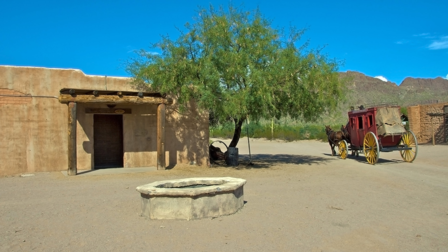
Not the movie studio it used to be, Old Tucson Studios remains a historical site
for movie buffs and a fun place for youth. Located just west of Tucson, Arizona,
adjacent to the Tucson Mountains and close to the western portion
of Saguaro National Park, the site was built in 1939 for the movie Arizona.
Last Friday, during James and Jill’s visit, we spent a beautiful, fun day
at the Old Tucson Studios. Not quite the same place as it was when
I first visited the Studios in 1968, but still a great place to take visitors.
The slideshow below contain twelve of thirty-one photos in my Flickr
Photo Set.
kenne
This slideshow requires JavaScript.

 Catalina Foothills Smoked-filled Sunset, Monday, June 20, 2011 — Image by kenne


Saguaro National Park
Cam-Boh Trail in the Saguaro National Park — Image by kenne
Tucson is located in the Sonoran Desert, one of the natural beauties of the American southwest and has one of our great National Parks, the Saguaro National Park. Since this is National Park Week, I would be remiss not to share some information on our neighbor park. The park is divided into two sections, lying about 20 miles east and 15 miles (24 km) west of the center of Tucson. Each section includes ranges of significant hills, the Tucson Mountains in the west and the Rincon Mountains in the east. The park gets its name from the saguaro cactus which is native to the region. Many other kinds of cactus, including barrel cactus, cholla cactus, and prickly pear, are also abundant in the park.
The park was established as Saguaro National Monument on March 1, 1933, and changed to a national park on October 14, 1994. For more information on the park, click here.
kenne
Share this:
Like this: