Paul and Jim On The Cam-Boa Trail Headed Toward Panther Peak — Image by kenne
We left the Cam-Boh Picnic Area , located off Picture Rocks Road, on the Cam-Boa trail at the western edge of the Tucson Mountain District of the Saguaro National Park – West. Part of this trail in the Panther Peak Wash, however we cut across the wash headed toward the draw or gully between Panther Peak and Sombrero Peak to the east. This time of year the floor of the desert is showing a lot of green from the early growth of desert wild-flowers.
Once near the base of the two peaks, the hike becomes a fun bush whack climb to the saddle between the peaks. This part of the park is beautiful, as is most of the Tucson Mountains — plenty of large saguaros, palo verde trees and cholla cactus. My hiking partners, Jim and Paul, shared time leading as we tried to pick the best route up through the draw, trying to spot an occasional cairn. Stopping along the way, I took several photos, some meant to form panorama images of the surrounding mountains.
Looking back down through the draw between Panther Peak and Sombrero Peak, with Wasson Peak in the distance.
This is a fun hike with beautiful views in every direction. People who know the area well can probably point out many of the southern Arizona landmarks. Click here to see a slide show of photos taken, Monday, January 9, 2012.
Paul and Jim At The Top Of Panther Peak — Images by kenne
Saguaro Cactus are large trees that live to be hundreds of years old. It is one of the defining plants of the Sonoran Desert. Like this Saguaro in Tanuri Ridge, these plants are giant, tree-like columnar cacti that develop branches (or arms) as they age, although some never grow arms. The number of arms and the likely age of this particular plant may have helped shorten this plant’s life due to the current long drought and unusually cold weather this past winter. Our Saguaro was one impressive plant when I first photographed it last November. I’m sure that over the life of this plant, it experienced harsh conditions, but none as severe as the previous nine months. Even with some of the arms reaching down to help support this giant (most Saguaro arms point up), our freaky weather took its toll.
Its many arms help depict many images in one’s “mind’s eye,” i.e., runners embracing one another at the finish line, or a symbol of, “He out heavy, he’s my brother.” Although the age of this plant is hard for this novice to determine, the Saguaro rarely grows its arms until after the age of 75. Definitely a slow maturer, the cactus only puts up a main stem or spike for three-quarters of a century, during which it might grow as high as a foot after fifteen years and even seven feet after fifty years. Yet, for many, they may still not have any arms. As the images show, this “big guy” in Tanuri Ridge had a lot of arms, all of which now lie helpless on the ground near the Rillito River.
This is a significant loss to those who walk the Tanuri Ridge trails along the riverside. However, as someone who loves to “capture the moment,” the two (several exist from each shooting) I have near the end of its long life only cause one to challenge the imagination as to other moments that might have been captured over the years. For example, at one time, there was running water in the river with large cottonwoods lining its edge — just imagine! Such imaginative moments are priceless.
Cam-Boh Trail in the Saguaro National Park — Image by kenne
Tucson is located in the Sonoran Desert, one of the natural beauties of the American southwest and has one of our great National Parks, the Saguaro National Park. Since this is National Park Week, I would be remiss not to share some information on our neighbor park. The park is divided into two sections, lying about 20 miles east and 15 miles (24 km) west of the center of Tucson. Each section includes ranges of significant hills, the Tucson Mountains in the west and the Rincon Mountains in the east. The park gets its name from the saguarocactus which is native to the region. Many other kinds of cactus, including barrel cactus, cholla cactus, and prickly pear, are also abundant in the park.
The park was established as Saguaro National Monument on March 1, 1933, and changed to a national park on October 14, 1994. For more information on the park, click here.
This annual event is held the Saturday before Thanksgiving. Participants can cycle 109, 79, 64 or 40 miles. This year over 8600 riders participated in the fundraising event. The cycle routes go through the scenic areas of Tucson, with beautiful vistas of its local mountain ranges – three rising over 9,000 feet complete with the backdrop of the mighty saguaro cactus, icon of the Southwest’s Sonoran Desert. To get a photographic feel for the annual event, I choose to photograph the nearby 64 mile start in the foothills and along Sunrise Drive.
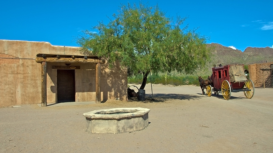
Not the movie studio it used to be, Old Tucson Studios remains a historical site
for movie buffs and a fun place for youth. Located just west of Tucson, Arizona,
adjacent to the Tucson Mountains and close to the western portion
of Saguaro National Park, the site was built in 1939 for the movie Arizona.
Last Friday, during James and Jill’s visit, we spent a beautiful, fun day
at the Old Tucson Studios. Not quite the same place as it was when
I first visited the Studios in 1968, but still a great place to take visitors.
The slideshow below contain twelve of thirty-one photos in my Flickr
Jeri, Virginia, Joy & Jody in the Saguaro National Park — Image by kenne
We have visitors from southern California, Joy’s sisters, Jeri and Jody; and her mom, Virginia.
We made a morning short drive to the Saguaro National Park, after which they have headed to the
Desert Diamond Casino till this evening — without me!

 Paul and Jim On The Cam-Boa Trail Headed Toward Panther Peak — Image by kenne

 My hiking partners, Jim and Paul, shared time leading as we tried to pick the best route up through the draw, trying to spot an occasional cairn. Stopping along the way, I took several photos, some meant to form panorama images of the surrounding mountains.
 My hiking partners, Jim and Paul, shared time leading as we tried to pick the best route up through the draw, trying to spot an occasional cairn. Stopping along the way, I took several photos, some meant to form panorama images of the surrounding mountains.


 Art II blog")
 blog")

-9 blog")


_painting blog")

 blog")
-4 blog")
-5 Balance Rock blog")
-5 blog")
-12 blog")
-5 blog")
 blog")

-4-2_contrast blog")


 blog")
-3 blog")


 blog")
-14 blog")


 blog")
-2 blog")
-6 blog")


-17 blog")
-2 blog")


-2 blog")
-9 blog")
 blog")
-art blog")
-8 blog")
 blog")

-2 blog")
-28 blog")
-5 blog")
-2 art blog")


-5 blog")
 framed blog")
 blog")

-5 blog")
 art blog")
-2 blog")

 blog")

-8 blog")


 art blog")

-27 blog")
-4 blog")


-2 Two Nuns blog")

-33 Pine Leaf Milkweed Pod blog")


 blog")
-6 blog")

-3 blog")


-2 blog")
-2 blog")

-11 blog")
 blog")


-2 blog")
-4 blog")
 blog")
-10 blog")
-2 blog")
 art blog")

 art blog")


")
Saguaro National Park
Cam-Boh Trail in the Saguaro National Park — Image by kenne
Tucson is located in the Sonoran Desert, one of the natural beauties of the American southwest and has one of our great National Parks, the Saguaro National Park. Since this is National Park Week, I would be remiss not to share some information on our neighbor park. The park is divided into two sections, lying about 20 miles east and 15 miles (24 km) west of the center of Tucson. Each section includes ranges of significant hills, the Tucson Mountains in the west and the Rincon Mountains in the east. The park gets its name from the saguaro cactus which is native to the region. Many other kinds of cactus, including barrel cactus, cholla cactus, and prickly pear, are also abundant in the park.
The park was established as Saguaro National Monument on March 1, 1933, and changed to a national park on October 14, 1994. For more information on the park, click here.
kenne
Share this:
Like this: